46°20'51.3"N 74°30'51.9"W
46.347571, -74.514429
To reserve this site, please go to the official Parcs Québec online reservation system.
Click on any photo for larger view.
Click on any photo for larger view.
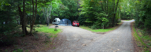
The site 38 is located in the Bacagnole area of the Parc national du Mont-Tremblant on the shores of Lac Monroe.
In the above photo you can see the site location in reference to the access road. You will arrive from your right on the one-way access road. There would be another line of the sites in the woods on your right between the gravel and the paved roads.
Looking the other way - the gravel access road continues. The outhouse and the water spigot are both located down the road three campsites away. The small public access beach is there as well.
This panorama photo gives you an idea of how deep is the site. The full size trailer will fit in with some room left in the back. The fire pit may be somewhat of an obstacle as it is located towards the entrance. Still, there is a lot of space.
The view from behind the trailer towards the entrance. You may be able to see the fire pit all the way by the entrance.
The open space on the left hand side is also part of the site. The path crossing that space leads to the water.
The path becomes steep as it gets closer to the water. It might be hard to drop your canoe or kayak off that steep shore. There is an option though. You can launch it from the small beach three sites away and then park it by your site.
You won't see much of the water from your site directly. But this is what you see after you follow that path and get to the water level.


